
Climbing Rangers in Yosemite spend much of our time patrolling the vertical wilderness. Typically these walls fall well within a few hours walk of the road since most climbers are loath to walk farther than that. That said, wilderness of Yosemite is vast, and climbable rock is found all over the map. Although day-use and campgrounds have been limited to help the park maintain Covid safe conditions, the wilderness permit quotas have been left unchanged. What better way to socially distance than a mountain romp? Nearly all wilderness permits have been claimed this summer and you can see the effects of an increase of visitation in wilderness. Over the past month I have been fortunate to help the wilderness patrol staff while exploring some of the far-flung climbing objectives Yosemite has to offer.

The Clark Range from the East
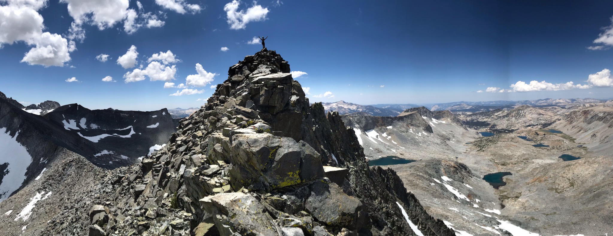
Clark Range
The first, was a four-day trip to traverse the Clark Range. The Clark Range stretches from Triple Divide Peak on the southern boundary of Yosemite past Merced, Ottoway, Red and Grey Peaks before culminating with Mount Clark. Named after historic Yosemite pioneer Galen Clark, Mt Clark is one of those mountains that stands out. The Serpentine NW Ridge winds its way to the lofty summit pinnacle, and its relative prominence has always reminded me of the lonely mountain from The Hobbit. Does a dragon guard buried treasure under the mountain? Be it childhood fantasies or just plain mountain inspiration Mt Clark appeals to me. KC Ellingford shared my enthusiasm for getting out and exploring the Clark Range, so we began to hatch our plans.
KC and I set out on July 13th towards Merced Lake. The sweeping granite exposures of Yosemite Valley continue into the upper Merced. Though smaller, there are numerous beautiful walls and domes lining the canyon. KC and I both suffer from acute line’s disease. The main symptom exhibits itself through an inability to walk past a sweep of rock without thoroughly examining it for climbing potential. Needless to say our hike in was long and slow. After a night spent in luxury at the Merced Lake Ranger Cabin, a backcountry outpost staffed by the inspiring Allison Van Dusen (more on her later), KC and I crossed the Merced River just below Merced Lake and began our long climb up Mt. Clark. The initial slabs are steep and unrelenting, eventually leveling off on a forested bench.

Admiring Mt Clark on the approach
Continuing up this bench we dropped into the basin on the north side of Mt Clark. This beautiful little basin, nestled just below the summit of Mt Clark, was in full bloom. Shooting stars, monkey flowers, and columbines in their respective habitats. I yearned to linger in this tranquil valley but to gain access to the NW Ridge our path veered through a broken notch and into the Whitebark Pine labyrinth above. We wound back and forth, finding passage through the krummholz trees, emerging below the summit pinnacle.
The upper NW Ridge opens into a bowl sporting a variety of possible routes. A sandy gully separates the spiny NW Ridge from a golden buttress to the west. All the various options converge on the enjoyable 4th class summit ridge, comprised of large golden blocks with awesome exposure. The remote setting, quality rock, and sublime exposure make Mt Clark a Yosemite backcountry classic.

The view looking south from the summit of Mt Clark
From the summit of Mt Clark, KC and I traversed the rocky crest of the ridge, slightly loose 3rd and 4th class climbing. While engaging and enjoyable, this section slowed us down. The best option is to descend to the lake in the NW bowl of Grey Peak. From there a beautiful 3rd class ridge rises above the lake to the summit of Grey. Upon arriving at the summit of Grey, the ridge-line leading to Red Peak unveiled itself. Craggy red ridges continued for another mile. Because of our pace along the ridge leading to Grey Peak we decided to take a more direct route to our planned camp at Red Devil Lake rather than push on into darkness. Having experienced perfect weather all day, why make ourselves suffer unnecessarily? Sometimes climbing rangers need to be bail rangers. Upon returning to civilization, the legendary Cameron King had good beta for making Red Peak an enjoyable jaunt. Like Grey peak, by descending to a lake nestled in the basin NW of Red Peak, a 3rd class ridge can be ascended bypassing more than a mile of loose rock.

Pika, Ochotonidae Ochotona
Our descent to Red Devil Lake followed steep scree gullies into a tarn filled basin, where we were greeted by the warning “cheeps” of pikas. Pika, objectively the cutest animal in the Sierra, are alpine hay farmers. With climate change affecting their habitat pika are a sensitive species in the Sierra. Living in talus fields, they collect grasses of different sorts for the long winter months. They have evolved the knowledge and practice of selecting a variety of grasses and carefully arranging their haystack with the longest lasting grasses buried behind the more perishable stems. Our progress to Red Devil Lake was announced by the “cheep, cheep” of more pika than I have heard in the Sierra. Perhaps the big winter two years ago helped the population rebound.

Sunrise reflection on Red Devil Lake
On our initial climb up Mt. Clark and again on the ridgeline between Clark and Grey Peak, we encountered knapped obsidian chips. Obsidian is a volcanic glass which fractures to form scalpel-like edges. Native Americans prized obsidian for arrowheads and other tools. With the nearest exposure of obsidian located in the Mono Basin 40 miles east, these fragments must have been transported by the native people of the Sierra. Humans have traveled the airy summits of the Clark Range and other mountains of the Sierra for centuries. Recognizing our place in this history of mountain travel lends perspective to our inspiration and drive to be among the peaks.
The following day, after swimming in the surprisingly warm waters of Red Devil Lake, we followed the Red Peak Fork to the trail along the Upper Merced River. Throughout the day puffy clouds steadily built. KC mused hopefully that these clouds may signal the start of the summer monsoon season. As the storm swallowed the ridgeline, we had gleefully traversed the day before, we were flooded with gratitude for the weather experienced on our traverse and the cabin awaiting us three miles down the trail.
That evening we shared the cabin with Allison Van Dusen. A 25-year veteran of wilderness protection, Allison has worked in 8 different national parks all over the west. We swapped stories over dinner about adventures near and far. With Allison recounting winters spent travelling the world, bike touring in France and caretaking sled dogs in Alaska to name a few. She is an inspiring woman, who has followed an unconventional path in her pursuit of her dreams.
Time spent in the mountains is always special. Getting to experience beautiful places in the mountains recharges and rejuvenates the soul. The people who we share those experiences with are equally important, and often lead to deep and strong connections.

Sunset on the Lyell Range
Cathedral and Lyell Zone
The following week Cameron King convinced me to clear my schedule and join him on another ramble through the Yosemite high country. After that first thunderstorm of the season KC and I experienced, a reliable storm cycle had settled onto the high country. Nearly every afternoon for two weeks cumulonimbus clouds had built into the stratosphere bringing rain, thunder and lightning. The forecast showed a chance of rain for the beginning of our four-day patrol, Cam and I decided to go ahead with our plan and hope for the best. We began our patrol on the John Muir Trail, heading south up Lyell Canyon to Donahue Pass. Lyell Canyon is the main headwaters of the Tuolumne River, beginning high in the Cathedral Range at the last remaining glacier in Yosemite National Park. The river meanders through broad flat meadows, the lack of elevation gain was a pleasant way to loosen up our bodies. The primary aim of the first two days of our trip were to perform a focus patrol at Donahue Pass. Focus patrols collect data about wilderness experience. The first half of the survey involves visiting each campsite at the Maclure Creek junction and counting the number of other people seen or heard. The second half of the patrol is to sit at Donahue Pass documenting each group of hikers. We were prepared for the patrol with plenty of coffee, snacks, and a cribbage board to pass the time. However, upon arriving our intended campsite we met a family about to call for a rescue. Cam took the lead, performing a patient assessment of the injured teenager. He was unable to put any weight on his injured ankle and with 11 miles to Tuolumne Meadows, hiking out under his own power was out of the question. We waited to call in a rescue until morning, to see if the injury would resolve itself with some rest. With no improvement overnight we called in the cavalry. Fred, a 50-year veteran ranger in Tuolumne was called in to do a “horse out”. The lucky patient was going to get the ride of a lifetime! To maintain communication, we decided to perform the second half of the focus patrol right there at the campsite. We settled in for the day snacks in reach, aero press primed, and cribbage board ready for pegging. After 8 hours of documenting hikers, and 2-1 record in my favor, two members of the Tuolumne SAR team arrived with crutches and medical supplies. They mobilized the patient in hopes of meeting the horses at the Maclure Creek junction, lessening the burden on the horses. Once relieved from patient care responsibilities we wrapped up the focus patrol and began the next leg of our journey.

The craggy East Ridge of Simmons Peak
Our next objective was to climb the East Ridge of Simmons Peak. The Peak lies along the ridge north of Mount Lyell and Maclure. A striking buttress that Cam had spied on a trip the year before, the Secor guide describes an enjoyable 5.8 ridge. The dark rock and craggy demeanor of Simmons is a far cry from the typical Yosemite fare, with more in common to the Palisades. Our alpine bivy, nestled next to a small lake with the Kuna Crest glowing in the evening light, couldn’t have been further from Yosemite Valley. The ridge looked steep and intimidating from our sleeping bags. The next morning, after depositing our packs on the ridge adjacent to the summit, we returned to the base and started up the ridge. We soon arrived at a small roof with a shallow corner above. Upon inspecting the other options, it became clear the route lay above us. I took our sparse rack tightened my approach shoes and began delicately smearing my way up to the roof. The rock was mostly good, if dirty, but without climbing shoes I was learning to walk again. I began to regret our decision to leave them in the car. Luckily, I was able to reach high past the roof to get a green alien into the most solid flake I could find, allowing me to pull the move in the relative security of a top rope. With that step behind us we were able to cruise the rest of the ridge. Alternating between blocky 4th class and pitches of quality 5th class scrambling the route was an enjoyable romp, although we both agreed the grade was more likely 5.8+++.

Admiring the precarious placement of a Bighorn Sheep’s bed
Along the summit ridge I encountered a dusty depression full of sheep scat. Sierra Bighorn Sheep disappeared from the Cathedral Range in the early 20th century due to competition and diseases brought up by the domestic sheep that grazed the high alpine meadows. In 2015 Bighorn were reintroduced to Yosemite National Park, and their population is holding steady. Bighorn, called “the bravest of all Sierra Mountaineers” by John Muir, are at home among the high mountains. They move with grace through steep and loose terrain. It is a challenging life, staying high in the mountains through the winter contending with winter storms and therefore sparse vegetation to forage. To see evidence of Bighorn in the mountains is a treat. Knowing we share these wild spaces with creatures far more adept than us, once again lends perspective to our place within these mountains.
After two days where thunderstorms graciously passed us by, clouds were quickly building. We hustled off the summit of Simmons dropping into the relative safety of the treeless Lewis Creek Drainage. We walked down the talus and slabs of the upper basin through a steady drizzle, fortunately that was all we encountered.

Admiring the Nightingale Arete
Because of the storm the day before, Cam and I got an early start in our approach to the Nightingale Arete on Vogelsang Peak. The arete strikes across the west face of Vogelsang Peak like a lightening bolt. I was aware of the route after having seen it numerous times from the trail below, but I had always been on Physical Science work trips and unable to investigate further. While eager to investigate such a beautiful feature I was trepidatious due to weather and the intensity of our 5.8 the day before. With a 5.9+ rating, our light rack and approach shoe silliness, the Nightengale Arete certainly had my attention. The approach leads to a small lake tucked at the base of the route. From the lake the arete rises in a steep lower buttress to gain the horizontal ridge traverse. Cam lead us up slabby terrain before encountering a steep corner. We climbed quickly to get us off the mountain before the thunder rolled. Rock quality on the lower buttress was very good, some superficial flakiness and lichen gave it an alpine feel, but the return to quality Tuolumne style granite was reassuring. The traverse to the upper buttress was mellow, staying along the crest is 3rd and 4th class with awesome exposure or if in a hurry the bench below allows for 2nd class walking to the stunning upper buttress. The first pitch off the traverse follows slabby finger cracks on the prow of the arete, with excellent rock quality and exposure. This pitch lands at the base of the steep 5.9+ crux corner. The steep hand crack takes good gear and is only about 30 feet long. After a short pitch, the difficulty eases substantially. The remaining climbing to the summit is surprisingly fun. Winding through giant blocks, the movement and gear are superb. Turns out, 5.9+ on solid rock with good pro is easier than obscure 5.8 in the mountains. By the time we summited at noon, dark clouds already covered the sky, we still had to follow the ridge higher to gain the descent trail to Vogelsang Pass. We hustled up the ridge, as fast as our weary legs would take us and finally dropped down the sandy basin to the trail and our camp at Vogelsang Lake. Fortunately, the storm held off until we were packed and moving down the trail. But once it moved in, it came with a fury of pent up energy. We kept moving since we were surrounded by high peaks and still had 7 miles to cover. Soon we were soaked by the rain and hail, lightening flashed on the summits of Parsons and Fletcher Peaks. With heads bowed, we slogged on through the rain, focused on staying warm and the tuna melts and beer waiting in the truck.
Vertical wilderness in Yosemite is all around us. Adventures can be had all over the map, not allowing the proximity of a road to limit a plan allows your creativity to blossom, molding yourself to fit what the mountains offer. The climbing rangers are part of a bigger team, protecting and preserving wilderness character all over Yosemite for future generations to experience novel, wild spaces.